{
	"@context": {
		"dcat": "http://www.w3.org/ns/dcat#",
		"dct": "http://purl.org/dc/terms/",
		"foaf": "http://xmlns.com/foaf/0.1/",
		"vcard": "http://www.w3.org/2006/vcard/ns#",
		"ftype": "http://publications.europa.eu/resource/authority/file-type/",
		"lang": "http://publications.europa.eu/resource/authority/language/",
		"skos": "http://www.w3.org/2004/02/skos/core#"
	},
	"@id": "https://www.interamericangeoportal.org",
	"@type": "dcat:Catalog",
	"dct:description": "Create your own initiative by combining existing applications with a custom site. Use this initiative to form teams around a problem and invite your community to participate.",
	"dct:title": "Inter-American GeoPortal",
	"dct:publisher": {
		"@type": "foaf:Agent",
		"foaf:name": "Americas GeoPortal - Core Organization"
	},
	"foaf:homepage": {
		"foaf:Document": "https://www.interamericangeoportal.org/search",
		"@type": "foaf:Document"
	},
	"dct:language": {
		"@id": "lang/ENG"
	},
	"dct:creator": {
		"@id": "https://americas.maps.arcgis.com",
		"@type": "foaf:Agent",
		"foaf:name": "Americas GeoPortal - Core Organization"
	},
	"dcat:dataset": [
		{
			"@type": "dcat:Dataset",
			"@id": "https://www.interamericangeoportal.org/pages/americas::geo-ai",
			"dct:title": "GEO-AI",
			"dct:description": "{{description}}",
			"dcat:contactPoint": {
				"@id": "https://americas.maps.arcgis.com/sharing/rest/community/users/Americas_GeoPortal?f=json",
				"@type": "vcard:Kind",
				"vcard:fn": "Americas_GeoPortal",
				"vcard:hasEmail": "{{orgContactEmail}}"
			},
			"dct:publisher": {
				"@type": "foaf:Agent",
				"foaf:name": "Americas GeoPortal - Core Organization"
			},
			"dcat:theme": {
				"@type": "skos:Concept",
				"skos:prefLabel": "Geospatial"
			},
			"dct:accessRights": {
				"@type": "dct:RightsStatement",
				"@label": {
					"@value": "public"
				}
			},
			"dct:identifier": "https://www.arcgis.com/home/item.html?id=77912cbb1ce64ff38e1f02b3f8e8518e",
			"dcat:keyword": [
				"ArcGIS Hub page"
			],
			"dct:provenance": {
				"@type": "dct:ProvenanceStatement",
				"@label": {
					"@value": ""
				}
			},
			"dct:issued": "2025-12-29T17:28:07.000Z",
			"dct:modified": "2026-11-05T21:56:45.000Z",
			"dct:language": {
				"@id": "lang/ENG"
			},
			"dct:spatial": {
				"@type": "dct:Location",
				"dct:bbox": [
					{
						"@value": "POLYGON((-134.7473,50.3092,-55.6955,50.3092,-55.6955,23.561,-134.7473,23.561,-134.7473,50.3092))",
						"@type": "opengis:wktLiteral"
					}
				]
			},
			"dcat:distribution": [
				{
					"@type": "dcat:Distribution",
					"dcat:accessURL": {
						"@id": "https://www.interamericangeoportal.org/pages/americas::geo-ai"
					},
					"dct:format": {
						"@id": "ftype/HTML"
					},
					"dct:description": "Web Page",
					"dct:title": "ArcGIS Hub Dataset"
				}
			]
		},
		{
			"@type": "dcat:Dataset",
			"@id": "https://www.interamericangeoportal.org/datasets/WorldPop::worldpop-population-density-2000-2020-100m",
			"dct:title": "WorldPop Population Density 2000-2020 100m",
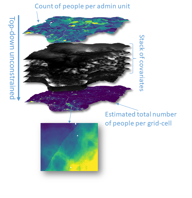
			"dct:description": "<p><span style='color:#b22222;'><strong>Retirement Notice</strong></span>: This item is in <a target='_blank' href='https://content.esri.com/support/techarticles/product-life-cycle.pdf' rel='nofollow ugc noopener noreferrer'><strong>mature support</strong></a> as of August 2026 and will retire in December 2027. Similar items are available in this <a target='_blank' href='https://www.arcgis.com/home/group.html?id=bfb8bfc29d824780b669949fb007aab3#overview' rel='nofollow ugc noopener noreferrer'>ArcGIS Online Group</a>. Esri and WorldPop recommend updating your maps and apps to use the new version.</p><p><span style='font-family:&quot;Avenir Next W01&quot;, &quot;Avenir Next W00&quot;, &quot;Avenir Next&quot;, Avenir, &quot;Helvetica Neue&quot;, sans-serif; font-size:16px;'>This layer contains&nbsp;</span><a target='_blank' href='https://www.worldpop.org' rel='nofollow ugc noopener noreferrer'>WorldPop's</a><span style='font-family:&quot;Avenir Next W01&quot;, &quot;Avenir Next W00&quot;, &quot;Avenir Next&quot;, Avenir, &quot;Helvetica Neue&quot;, sans-serif; font-size:16px;'>&nbsp;100m resolution annual estimates of population density from the year 2000 to 2020.&nbsp;</span></p><p><strong>Usage notes</strong><span style='font-family:&quot;Avenir Next W01&quot;, &quot;Avenir Next W00&quot;, &quot;Avenir Next&quot;, Avenir, &quot;Helvetica Neue&quot;, sans-serif; font-size:16px;'>:&nbsp;</span></p><ul><li><span style='font-family:&quot;Avenir Next W01&quot;, &quot;Avenir Next W00&quot;, &quot;Avenir Next&quot;, Avenir, &quot;Helvetica Neue&quot;, sans-serif; font-size:16px;'>This layer is configured to be viewed only at a scale range for large-scale maps, i.e., zoomed into small areas of the world.&nbsp;</span></li><li><span style='font-family:&quot;Avenir Next W01&quot;, &quot;Avenir Next W00&quot;, &quot;Avenir Next&quot;, Avenir, &quot;Helvetica Neue&quot;, sans-serif; font-size:16px;'>Because the underlying data for this layer is relatively large and because raster pyramids cannot accurately represent aggregated population density, there are no pyramids. Thus, this layer may at times require 10 to 15 seconds to draw.&nbsp;&nbsp;</span></li><li><span style='font-family:&quot;Avenir Next W01&quot;, &quot;Avenir Next W00&quot;, &quot;Avenir Next&quot;, Avenir, &quot;Helvetica Neue&quot;, sans-serif; font-size:medium;'>We recommend using this layer in conjunction with&nbsp;</span><a target='_blank' href='https://www.arcgis.com/home/item.html?id=38b7672a1977426caa6cf4c62e37b777' rel='nofollow ugc noopener noreferrer'><span style='font-size:medium;'>WorldPop's 1-km resolution Population Density layer</span></a><span style='font-family:&quot;Avenir Next W01&quot;, &quot;Avenir Next W00&quot;, &quot;Avenir Next&quot;, Avenir, &quot;Helvetica Neue&quot;, sans-serif; font-size:medium;'>&nbsp;to create web maps that allow users to pan and zoom to wider areas; this&nbsp;</span><a target='_blank' href='https://www.arcgis.com/home/item.html?id=f9cb5e481ecc48bfbdd6486c42e19a24' rel='nofollow ugc noopener noreferrer'><span style='font-family:&quot;Avenir Next W01&quot;, &quot;Avenir Next W00&quot;, &quot;Avenir Next&quot;, Avenir, &quot;Helvetica Neue&quot;, sans-serif; font-size:medium;'>web map</span></a><span style='font-family:&quot;Avenir Next W01&quot;, &quot;Avenir Next W00&quot;, &quot;Avenir Next&quot;, Avenir, &quot;Helvetica Neue&quot;, sans-serif; font-size:medium;'>&nbsp;contains an example of this combination.&nbsp;</span></li></ul><p>&nbsp;</p><p><span style='font-family:Avenir Next W01, Avenir Next W00, Avenir Next, Avenir, Helvetica Neue, sans-serif; font-size:16px;'>The population estimates in this layer are derived WorldPop's total population data, which use a&nbsp;</span><a target='_blank' href='https://www.worldpop.org/methods/top_down_constrained_vs_unconstrained' rel='nofollow ugc noopener noreferrer'>Top-down unconstrained method</a><span style='font-family:Avenir Next W01, Avenir Next W00, Avenir Next, Avenir, Helvetica Neue, sans-serif; font-size:16px;'>&nbsp;which estimates the total population for each cell with a Random Forest-based dasymetric model (Stevens, F. R., Gaughan, A. E., Linard, C., &amp; Tatem, A. J. (2015).&nbsp;</span><a target='_blank' href='https://journals.plos.org/plosone/article?id=10.1371%2fjournal.pone.0107042&amp;msclkid=e680f12ec18d11ec9d35ec3fdcf85b40' rel='nofollow ugc noopener noreferrer'>Disaggregating census data for population mapping using random forests with remotely-sensed and ancillary data</a><span style='font-family:Avenir Next W01, Avenir Next W00, Avenir Next, Avenir, Helvetica Neue, sans-serif; font-size:16px;'>. PloS one, 10(2), e0107042</span><span style='font-family:&quot;Avenir Next W01&quot;, &quot;Avenir Next W00&quot;, &quot;Avenir Next&quot;, Avenir, &quot;Helvetica Neue&quot;, sans-serif; font-size:16px;'>) and converts these values to population density by dividing the number of people in each pixel by the pixel surface area.&nbsp;This diagram visually describes this model that uses known populated locations to analyze imagery to find similarly populated locations.&nbsp;</span></p><p style='text-align:center;'><img src='https://data.worldpop.org/tmp/top_down_unconstrained_v1.png' alt='top down unconstrained' /><br />&nbsp;</p><p><span style='font-family:&quot;Avenir Next W01&quot;, &quot;Avenir Next W00&quot;, &quot;Avenir Next&quot;, Avenir, &quot;Helvetica Neue&quot;, sans-serif; font-size:16px;'>The DOI for the original WorldPop.org total population population data</span>&nbsp;is&nbsp;<a target='_blank' href='https://www.worldpop.org/doi/10.5258/SOTON/WP00645' rel='nofollow ugc noopener noreferrer'>10.5258/SOTON/WP00645</a>.</p><p><strong>Recommended Citation:</strong> WorldPop (www.worldpop.org - School of Geography and Environmental Science, University of Southampton; Department of Geography and Geosciences, University of Louisville; Departement de Geographie, Universite de Namur) and Center for International Earth Science Information Network (CIESIN), Columbia University (2018). Global High Resolution Population Denominators Project - Funded by The Bill and Melinda Gates Foundation. Accessed from https://worldpop.arcgis.com/arcgis/rest/services/WorldPop_Total_Population_100m/ImageServer, which was acquired from WorldPop in December 2021.</p>",
			"dcat:contactPoint": {
				"@id": "https://americas.maps.arcgis.com/sharing/rest/community/users/WorldPop_Project?f=json",
				"@type": "vcard:Kind",
				"vcard:fn": "WorldPop_Project",
				"vcard:hasEmail": "mailto:noreply@worldpop.org"
			},
			"dct:publisher": {
				"@type": "foaf:Agent",
				"foaf:name": "Americas GeoPortal - Core Organization"
			},
			"dcat:theme": {
				"@type": "skos:Concept",
				"skos:prefLabel": "Geospatial"
			},
			"dct:accessRights": {
				"@type": "dct:RightsStatement",
				"@label": {
					"@value": "public"
				}
			},
			"dct:identifier": "https://www.arcgis.com/home/item.html?id=c90197b8948948d7b2194e1b03b11d1e",
			"dcat:keyword": [
				"WorldPop",
				"worldpop_soton",
				"Dasymetric",
				"Population",
				"retiring-2027-12"
			],
			"dct:provenance": {
				"@type": "dct:ProvenanceStatement",
				"@label": {
					"@value": ""
				}
			},
			"dct:issued": "2022-03-01T17:25:29.000Z",
			"dct:modified": "2026-08-10T18:34:55.000Z",
			"dct:language": {
				"@id": "lang/ENG"
			},
			"dct:spatial": {
				"@type": "dct:Location",
				"dct:bbox": [
					{
						"@value": "POLYGON((-180,83.6287,180,83.6287,180,-72.0009,-180,-72.0009,-180,83.6287))",
						"@type": "opengis:wktLiteral"
					}
				]
			},
			"dcat:distribution": [
				{
					"@type": "dcat:Distribution",
					"dcat:accessURL": {
						"@id": "https://www.interamericangeoportal.org/datasets/WorldPop::worldpop-population-density-2000-2020-100m"
					},
					"dct:format": {
						"@id": "ftype/HTML"
					},
					"dct:description": "Web Page",
					"dct:title": "ArcGIS Hub Dataset"
				},
				{
					"@type": "dcat:Distribution",
					"dcat:accessURL": {
						"@id": "https://worldpop.arcgis.com/arcgis/rest/services/WorldPop_Population_Density_100m/ImageServer"
					},
					"dct:format": {
						"@id": "ftype/JSON"
					},
					"dct:description": "Esri REST",
					"dct:title": "ArcGIS GeoService"
				}
			]
		},
		{
			"@type": "dcat:Dataset",
			"@id": "https://www.interamericangeoportal.org/pages/americas::learn",
			"dct:title": "Learn",
			"dct:description": "{{description}}",
			"dcat:contactPoint": {
				"@id": "https://americas.maps.arcgis.com/sharing/rest/community/users/SeanKMcGinnis_Americas?f=json",
				"@type": "vcard:Kind",
				"vcard:fn": "SeanKMcGinnis_Americas",
				"vcard:hasEmail": "{{orgContactEmail}}"
			},
			"dct:publisher": {
				"@type": "foaf:Agent",
				"foaf:name": "Americas GeoPortal - Core Organization"
			},
			"dcat:theme": {
				"@type": "skos:Concept",
				"skos:prefLabel": "Geospatial"
			},
			"dct:accessRights": {
				"@type": "dct:RightsStatement",
				"@label": {
					"@value": "public"
				}
			},
			"dct:identifier": "https://www.arcgis.com/home/item.html?id=ed55a4a8761742dd8614520846d680ed",
			"dcat:keyword": [
				"ArcGIS Hub page"
			],
			"dct:provenance": {
				"@type": "dct:ProvenanceStatement",
				"@label": {
					"@value": ""
				}
			},
			"dct:issued": "2021-04-05T19:00:49.000Z",
			"dct:modified": "2025-12-29T23:11:37.000Z",
			"dct:language": {
				"@id": "lang/ENG"
			},
			"dct:spatial": {
				"@type": "dct:Location",
				"dct:bbox": [
					{
						"@value": "",
						"@type": "opengis:wktLiteral"
					}
				]
			},
			"dcat:distribution": [
				{
					"@type": "dcat:Distribution",
					"dcat:accessURL": {
						"@id": "https://www.interamericangeoportal.org/pages/americas::learn"
					},
					"dct:format": {
						"@id": "ftype/HTML"
					},
					"dct:description": "Web Page",
					"dct:title": "ArcGIS Hub Dataset"
				}
			]
		},
		{
			"@type": "dcat:Dataset",
			"@id": "https://www.interamericangeoportal.org/pages/americas::geospatialtools",
			"dct:title": "GeospatialTools",
			"dct:description": "{{description}}",
			"dcat:contactPoint": {
				"@id": "https://americas.maps.arcgis.com/sharing/rest/community/users/SeanKMcGinnis_Americas?f=json",
				"@type": "vcard:Kind",
				"vcard:fn": "SeanKMcGinnis_Americas",
				"vcard:hasEmail": "{{orgContactEmail}}"
			},
			"dct:publisher": {
				"@type": "foaf:Agent",
				"foaf:name": "Americas GeoPortal - Core Organization"
			},
			"dcat:theme": {
				"@type": "skos:Concept",
				"skos:prefLabel": "Geospatial"
			},
			"dct:accessRights": {
				"@type": "dct:RightsStatement",
				"@label": {
					"@value": "public"
				}
			},
			"dct:identifier": "https://www.arcgis.com/home/item.html?id=52d0bc0a648443dfa38da93dc813a831",
			"dcat:keyword": [
				"ArcGIS Hub page"
			],
			"dct:provenance": {
				"@type": "dct:ProvenanceStatement",
				"@label": {
					"@value": ""
				}
			},
			"dct:issued": "2021-04-05T18:58:10.000Z",
			"dct:modified": "2025-12-29T23:11:15.000Z",
			"dct:language": {
				"@id": "lang/ENG"
			},
			"dct:spatial": {
				"@type": "dct:Location",
				"dct:bbox": [
					{
						"@value": "",
						"@type": "opengis:wktLiteral"
					}
				]
			},
			"dcat:distribution": [
				{
					"@type": "dcat:Distribution",
					"dcat:accessURL": {
						"@id": "https://www.interamericangeoportal.org/pages/americas::geospatialtools"
					},
					"dct:format": {
						"@id": "ftype/HTML"
					},
					"dct:description": "Web Page",
					"dct:title": "ArcGIS Hub Dataset"
				}
			]
		},
		{
			"@type": "dcat:Dataset",
			"@id": "https://www.interamericangeoportal.org/pages/americas::inter-american-living-atlas",
			"dct:title": "Inter-American Living Atlas",
			"dct:description": "{{description}}",
			"dcat:contactPoint": {
				"@id": "https://americas.maps.arcgis.com/sharing/rest/community/users/SeanKMcGinnis_Americas?f=json",
				"@type": "vcard:Kind",
				"vcard:fn": "SeanKMcGinnis_Americas",
				"vcard:hasEmail": "{{orgContactEmail}}"
			},
			"dct:publisher": {
				"@type": "foaf:Agent",
				"foaf:name": "Americas GeoPortal - Core Organization"
			},
			"dcat:theme": {
				"@type": "skos:Concept",
				"skos:prefLabel": "Geospatial"
			},
			"dct:accessRights": {
				"@type": "dct:RightsStatement",
				"@label": {
					"@value": "public"
				}
			},
			"dct:identifier": "https://www.arcgis.com/home/item.html?id=4a6faa6869ba40d595981c227d01a51f",
			"dcat:keyword": [
				"ArcGIS Hub page"
			],
			"dct:provenance": {
				"@type": "dct:ProvenanceStatement",
				"@label": {
					"@value": ""
				}
			},
			"dct:issued": "2021-04-05T18:55:36.000Z",
			"dct:modified": "2025-12-29T23:10:42.000Z",
			"dct:language": {
				"@id": "lang/ENG"
			},
			"dct:spatial": {
				"@type": "dct:Location",
				"dct:bbox": [
					{
						"@value": "",
						"@type": "opengis:wktLiteral"
					}
				]
			},
			"dcat:distribution": [
				{
					"@type": "dcat:Distribution",
					"dcat:accessURL": {
						"@id": "https://www.interamericangeoportal.org/pages/americas::inter-american-living-atlas"
					},
					"dct:format": {
						"@id": "ftype/HTML"
					},
					"dct:description": "Web Page",
					"dct:title": "ArcGIS Hub Dataset"
				}
			]
		},
		{
			"@type": "dcat:Dataset",
			"@id": "https://www.interamericangeoportal.org/maps/esri::openstreetmap-2",
			"dct:title": "OpenStreetMap",
			"dct:description": "<div><div style='margin-bottom:3.1rem;'><div style='display:inherit; max-width:100%;'><p style='margin-bottom:1.55rem; margin-top:0px;'><span style='color:#b22222;'><font style='font-family:&quot;Avenir Next W01&quot;, &quot;Avenir Next W00&quot;, &quot;Avenir Next&quot;, Avenir, &quot;Helvetica Neue&quot;, sans-serif; font-size:16px;'><strong>Mature Support Notice:</strong></font></span><span style='color:#dc143c;'><font style='font-family:&quot;Avenir Next W01&quot;, &quot;Avenir Next W00&quot;, &quot;Avenir Next&quot;, Avenir, &quot;Helvetica Neue&quot;, sans-serif; font-size:16px;'><strong>&nbsp;</strong></font></span><span style='font-family:&quot;Avenir Next W01&quot;, &quot;Avenir Next W00&quot;, &quot;Avenir Next&quot;, Avenir, &quot;Helvetica Neue&quot;, sans-serif; font-size:16px;'><strong>This item is in&nbsp;</strong></span><a style='color:rgb(0, 97, 155); font-family:&quot;Avenir Next W01&quot;, &quot;Avenir Next W00&quot;, &quot;Avenir Next&quot;, Avenir, &quot;Helvetica Neue&quot;, sans-serif; font-size:16px; text-decoration-line:none;' target='_blank' href='https://goto.arcgis.com/lifecycle/content' rel='nofollow ugc noopener noreferrer'><strong>mature support</strong></a><span style='font-family:&quot;Avenir Next W01&quot;, &quot;Avenir Next W00&quot;, &quot;Avenir Next&quot;, Avenir, &quot;Helvetica Neue&quot;, sans-serif; font-size:16px;'><strong>&nbsp;as of December 2024. </strong></span><span style='background-color:rgb(255,255,255); color:rgb(74,74,74); font-family:&quot;Avenir Next W01&quot;, &quot;Avenir Next W00&quot;, &quot;Avenir Next&quot;, Avenir, &quot;Helvetica Neue&quot;, sans-serif; font-size:16px;'><span style='border:0px solid currentcolor; box-sizing:border-box; font-style:normal; font-variant-caps:normal; font-variant-ligatures:normal; font-weight:400; letter-spacing:normal; line-height:1.5; text-align:start; text-decoration-color:initial; text-decoration-style:initial; text-indent:0px; text-transform:none; word-spacing:0px;'><strong>A&nbsp;</strong></span></span><a style='background-color:rgb(255, 255, 255); border:0px solid currentcolor; box-sizing:border-box; color:rgb(0, 97, 155); font-family:&quot;Avenir Next&quot;, Avenir, &quot;Helvetica Neue&quot;, sans-serif; font-size:16px; font-style:normal; font-variant-caps:normal; font-variant-ligatures:normal; font-weight:400; letter-spacing:normal; line-height:1.5; text-align:start; text-decoration:none; text-indent:0px; text-transform:none; word-spacing:0px;' target='_blank' href='https://www.arcgis.com/home/item.html?id=afa007556f2e4d66831d1e9b693e023e' rel='nofollow ugc noopener noreferrer'><strong>new version of this item</strong></a><span style='background-color:rgb(255,255,255); color:rgb(74,74,74); font-family:&quot;Avenir Next W01&quot;, &quot;Avenir Next W00&quot;, &quot;Avenir Next&quot;, Avenir, &quot;Helvetica Neue&quot;, sans-serif; font-size:16px;'><span style='border:0px solid currentcolor; box-sizing:border-box; font-style:normal; font-variant-caps:normal; font-variant-ligatures:normal; font-weight:400; letter-spacing:normal; line-height:1.5; text-align:start; text-decoration-color:initial; text-decoration-style:initial; text-indent:0px; text-transform:none; word-spacing:0px;'><strong>&nbsp;is available for your use. </strong>Esri recommends updating your maps and apps to use the new version. </span></span><span style='font-family:&quot;Avenir Next W01&quot;, &quot;Avenir Next W00&quot;, &quot;Avenir Next&quot;, Avenir, &quot;Helvetica Neue&quot;, sans-serif; font-size:16px;'>See&nbsp;</span><a style='color:rgb(0, 97, 155); font-family:&quot;Avenir Next W01&quot;, &quot;Avenir Next W00&quot;, &quot;Avenir Next&quot;, Avenir, &quot;Helvetica Neue&quot;, sans-serif; font-size:16px; text-decoration-line:none;' target='_blank' href='https://goto.arcgis.com/blogs/osmmaturesupport' rel='nofollow ugc noopener noreferrer'>blog</a><span style='font-family:inherit; font-size:14px;'>&nbsp;</span><span style='font-family:&quot;Avenir Next W01&quot;, &quot;Avenir Next W00&quot;, &quot;Avenir Next&quot;, Avenir, &quot;Helvetica Neue&quot;, sans-serif; font-size:16px;'>for more information.</span></p><p style='margin-bottom:0px; margin-top:10px; padding:0px;'>This world basemap presents OpenStreetMap (OSM) data hosted by Esri. This version of the map is rendered using OSM cartography.&nbsp;<span style='font-family:&quot;Avenir Next W01&quot;, &quot;Avenir Next W00&quot;, &quot;Avenir Next&quot;, Avenir, &quot;Helvetica Neue&quot;, sans-serif; font-size:16px;'>Created from the&nbsp;</span><a style='color:rgb(0, 97, 155); font-family:inherit; font-size:16px; text-decoration-line:none;' target='_blank' href='https://daylightmap.org/2024/05/03/sunsetting-daylight.html' rel='nofollow ugc noopener noreferrer'>sunsetted Daylight map distribution</a><span style='font-family:&quot;Avenir Next W01&quot;, &quot;Avenir Next W00&quot;, &quot;Avenir Next&quot;, Avenir, &quot;Helvetica Neue&quot;, sans-serif; font-size:16px;'>, data updates supporting this layer are no longer available.</span></p><div style='font-family:inherit; font-size:16px;'><div style='font-family:inherit;'>&nbsp;</div><div style='font-family:inherit;'>OpenStreetMap is an open collaborative project to create a free editable map of the world. Volunteers gather location data using GPS, local knowledge, and other free sources of information and upload it. The resulting free map can be viewed and downloaded from the OpenStreetMap site: www.OpenStreetMap.org. Esri is a supporter of the OSM project.&nbsp;</div></div></div></div></div><div style='display:inherit; font-family:&quot;Avenir Next W01&quot;, &quot;Avenir Next W00&quot;, &quot;Avenir Next&quot;, Avenir, &quot;Helvetica Neue&quot;, sans-serif; font-size:17px; margin-bottom:3.1rem;'><div style='display:inherit;'>&nbsp;</div></div>",
			"dcat:contactPoint": {
				"@id": "https://americas.maps.arcgis.com/sharing/rest/community/users/esri_vector?f=json",
				"@type": "vcard:Kind",
				"vcard:fn": "esri_vector",
				"vcard:hasEmail": "{{orgContactEmail}}"
			},
			"dct:publisher": {
				"@type": "foaf:Agent",
				"foaf:name": "Americas GeoPortal - Core Organization"
			},
			"dcat:theme": {
				"@type": "skos:Concept",
				"skos:prefLabel": "Geospatial"
			},
			"dct:accessRights": {
				"@type": "dct:RightsStatement",
				"@label": {
					"@value": "public"
				}
			},
			"dct:identifier": "https://www.arcgis.com/home/item.html?id=fae788aa91e54244b161b59725dcbb2a",
			"dcat:keyword": [
				"basemap",
				"OpenStreetMap",
				"OSM",
				"osmOpenstreetmap",
				"wma",
				"vector"
			],
			"dct:provenance": {
				"@type": "dct:ProvenanceStatement",
				"@label": {
					"@value": ""
				}
			},
			"dct:issued": "2018-06-21T23:52:23.000Z",
			"dct:modified": "2025-08-29T10:21:08.000Z",
			"dct:language": {
				"@id": "lang/ENG"
			},
			"dct:spatial": {
				"@type": "dct:Location",
				"dct:bbox": [
					{
						"@value": "POLYGON((-0.1732,51.518,-0.1098,51.518,-0.1098,51.4957,-0.1732,51.4957,-0.1732,51.518))",
						"@type": "opengis:wktLiteral"
					}
				]
			},
			"dcat:distribution": [
				{
					"@type": "dcat:Distribution",
					"dcat:accessURL": {
						"@id": "https://www.interamericangeoportal.org/maps/esri::openstreetmap-2"
					},
					"dct:format": {
						"@id": "ftype/HTML"
					},
					"dct:description": "Web Page",
					"dct:title": "ArcGIS Hub Dataset"
				}
			]
		},
		{
			"@type": "dcat:Dataset",
			"@id": "https://www.interamericangeoportal.org/apps/americasgp::community-survey-results",
			"dct:title": "Community Survey Results",
			"dct:description": "",
			"dcat:contactPoint": {
				"@id": "https://americas.maps.arcgis.com/sharing/rest/community/users/bhorne_americasgp?f=json",
				"@type": "vcard:Kind",
				"vcard:fn": "bhorne_americasgp",
				"vcard:hasEmail": "{{orgContactEmail}}"
			},
			"dct:publisher": {
				"@type": "foaf:Agent",
				"foaf:name": "Americas GeoPortal - Core Organization"
			},
			"dcat:theme": {
				"@type": "skos:Concept",
				"skos:prefLabel": "Geospatial"
			},
			"dct:accessRights": {
				"@type": "dct:RightsStatement",
				"@label": {
					"@value": "public"
				}
			},
			"dct:identifier": "https://www.arcgis.com/home/item.html?id=c0edfd90027a4e5c87c8c4223cac2b9f",
			"dcat:keyword": [
				""
			],
			"dct:provenance": {
				"@type": "dct:ProvenanceStatement",
				"@label": {
					"@value": ""
				}
			},
			"dct:issued": "2022-06-29T15:58:35.000Z",
			"dct:modified": "2022-08-29T20:59:09.000Z",
			"dct:language": {
				"@id": "lang/ENG"
			},
			"dct:spatial": {
				"@type": "dct:Location",
				"dct:bbox": [
					{
						"@value": "",
						"@type": "opengis:wktLiteral"
					}
				]
			},
			"dcat:distribution": [
				{
					"@type": "dcat:Distribution",
					"dcat:accessURL": {
						"@id": "https://www.interamericangeoportal.org/apps/americasgp::community-survey-results"
					},
					"dct:format": {
						"@id": "ftype/HTML"
					},
					"dct:description": "Web Page",
					"dct:title": "ArcGIS Hub Dataset"
				}
			]
		},
		{
			"@type": "dcat:Dataset",
			"@id": "https://www.interamericangeoportal.org/feedback/surveys/americasgp::inter-american-geoportal-community-survey",
			"dct:title": "Inter-American GeoPortal Community Survey",
			"dct:description": "{{description}}",
			"dcat:contactPoint": {
				"@id": "https://americas.maps.arcgis.com/sharing/rest/community/users/bhorne_americasgp?f=json",
				"@type": "vcard:Kind",
				"vcard:fn": "bhorne_americasgp",
				"vcard:hasEmail": "{{orgContactEmail}}"
			},
			"dct:publisher": {
				"@type": "foaf:Agent",
				"foaf:name": "Americas GeoPortal - Core Organization"
			},
			"dcat:theme": {
				"@type": "skos:Concept",
				"skos:prefLabel": "Geospatial"
			},
			"dct:accessRights": {
				"@type": "dct:RightsStatement",
				"@label": {
					"@value": "public"
				}
			},
			"dct:identifier": "https://www.arcgis.com/home/item.html?id=e258f710bf0544cc91c064af242bf904",
			"dcat:keyword": [
				"Survey123"
			],
			"dct:provenance": {
				"@type": "dct:ProvenanceStatement",
				"@label": {
					"@value": ""
				}
			},
			"dct:issued": "2022-06-27T21:38:06.000Z",
			"dct:modified": "2022-07-21T18:01:38.000Z",
			"dct:language": {
				"@id": "lang/ENG"
			},
			"dct:spatial": {
				"@type": "dct:Location",
				"dct:bbox": [
					{
						"@value": "",
						"@type": "opengis:wktLiteral"
					}
				]
			},
			"dcat:distribution": [
				{
					"@type": "dcat:Distribution",
					"dcat:accessURL": {
						"@id": "https://www.interamericangeoportal.org/feedback/surveys/americasgp::inter-american-geoportal-community-survey"
					},
					"dct:format": {
						"@id": "ftype/HTML"
					},
					"dct:description": "Web Page",
					"dct:title": "ArcGIS Hub Dataset"
				}
			]
		},
		{
			"@type": "dcat:Dataset",
			"@id": "https://www.interamericangeoportal.org/pages/americasgp::available-tools",
			"dct:title": "available-tools",
			"dct:description": "{{description}}",
			"dcat:contactPoint": {
				"@id": "https://americas.maps.arcgis.com/sharing/rest/community/users/m_obrien_americasgp?f=json",
				"@type": "vcard:Kind",
				"vcard:fn": "m_obrien_americasgp",
				"vcard:hasEmail": "{{orgContactEmail}}"
			},
			"dct:publisher": {
				"@type": "foaf:Agent",
				"foaf:name": "Americas GeoPortal - Core Organization"
			},
			"dcat:theme": {
				"@type": "skos:Concept",
				"skos:prefLabel": "Geospatial"
			},
			"dct:accessRights": {
				"@type": "dct:RightsStatement",
				"@label": {
					"@value": "public"
				}
			},
			"dct:identifier": "https://www.arcgis.com/home/item.html?id=72cf6e00ff0c4792bf46452f3e1829d0",
			"dcat:keyword": [
				"ArcGIS Hub page"
			],
			"dct:provenance": {
				"@type": "dct:ProvenanceStatement",
				"@label": {
					"@value": ""
				}
			},
			"dct:issued": "2022-06-29T16:42:03.000Z",
			"dct:modified": "2022-07-01T19:51:44.000Z",
			"dct:language": {
				"@id": "lang/ENG"
			},
			"dct:spatial": {
				"@type": "dct:Location",
				"dct:bbox": [
					{
						"@value": "",
						"@type": "opengis:wktLiteral"
					}
				]
			},
			"dcat:distribution": [
				{
					"@type": "dcat:Distribution",
					"dcat:accessURL": {
						"@id": "https://www.interamericangeoportal.org/pages/americasgp::available-tools"
					},
					"dct:format": {
						"@id": "ftype/HTML"
					},
					"dct:description": "Web Page",
					"dct:title": "ArcGIS Hub Dataset"
				}
			]
		},
		{
			"@type": "dcat:Dataset",
			"@id": "https://www.interamericangeoportal.org/pages/americas::open-street-map",
			"dct:title": "Open Street Map",
			"dct:description": "{{description}}",
			"dcat:contactPoint": {
				"@id": "https://americas.maps.arcgis.com/sharing/rest/community/users/SeanKMcGinnis_Americas?f=json",
				"@type": "vcard:Kind",
				"vcard:fn": "SeanKMcGinnis_Americas",
				"vcard:hasEmail": "{{orgContactEmail}}"
			},
			"dct:publisher": {
				"@type": "foaf:Agent",
				"foaf:name": "Americas GeoPortal - Core Organization"
			},
			"dcat:theme": {
				"@type": "skos:Concept",
				"skos:prefLabel": "Geospatial"
			},
			"dct:accessRights": {
				"@type": "dct:RightsStatement",
				"@label": {
					"@value": "public"
				}
			},
			"dct:identifier": "https://www.arcgis.com/home/item.html?id=f2ca3db0519e4779aa6bbfec41aba083",
			"dcat:keyword": [
				"ArcGIS Hub page"
			],
			"dct:provenance": {
				"@type": "dct:ProvenanceStatement",
				"@label": {
					"@value": ""
				}
			},
			"dct:issued": "2021-04-05T19:16:01.000Z",
			"dct:modified": "2022-06-30T23:08:45.000Z",
			"dct:language": {
				"@id": "lang/ENG"
			},
			"dct:spatial": {
				"@type": "dct:Location",
				"dct:bbox": [
					{
						"@value": "",
						"@type": "opengis:wktLiteral"
					}
				]
			},
			"dcat:distribution": [
				{
					"@type": "dcat:Distribution",
					"dcat:accessURL": {
						"@id": "https://www.interamericangeoportal.org/pages/americas::open-street-map"
					},
					"dct:format": {
						"@id": "ftype/HTML"
					},
					"dct:description": "Web Page",
					"dct:title": "ArcGIS Hub Dataset"
				}
			]
		},
		{
			"@type": "dcat:Dataset",
			"@id": "https://www.interamericangeoportal.org/pages/americas::field-mobility",
			"dct:title": "Field Mobility",
			"dct:description": "{{description}}",
			"dcat:contactPoint": {
				"@id": "https://americas.maps.arcgis.com/sharing/rest/community/users/SeanKMcGinnis_Americas?f=json",
				"@type": "vcard:Kind",
				"vcard:fn": "SeanKMcGinnis_Americas",
				"vcard:hasEmail": "{{orgContactEmail}}"
			},
			"dct:publisher": {
				"@type": "foaf:Agent",
				"foaf:name": "Americas GeoPortal - Core Organization"
			},
			"dcat:theme": {
				"@type": "skos:Concept",
				"skos:prefLabel": "Geospatial"
			},
			"dct:accessRights": {
				"@type": "dct:RightsStatement",
				"@label": {
					"@value": "public"
				}
			},
			"dct:identifier": "https://www.arcgis.com/home/item.html?id=1522de88d46f46549a808c625687401d",
			"dcat:keyword": [
				"ArcGIS Hub page"
			],
			"dct:provenance": {
				"@type": "dct:ProvenanceStatement",
				"@label": {
					"@value": ""
				}
			},
			"dct:issued": "2021-04-05T19:56:19.000Z",
			"dct:modified": "2022-06-30T23:07:16.000Z",
			"dct:language": {
				"@id": "lang/ENG"
			},
			"dct:spatial": {
				"@type": "dct:Location",
				"dct:bbox": [
					{
						"@value": "",
						"@type": "opengis:wktLiteral"
					}
				]
			},
			"dcat:distribution": [
				{
					"@type": "dcat:Distribution",
					"dcat:accessURL": {
						"@id": "https://www.interamericangeoportal.org/pages/americas::field-mobility"
					},
					"dct:format": {
						"@id": "ftype/HTML"
					},
					"dct:description": "Web Page",
					"dct:title": "ArcGIS Hub Dataset"
				}
			]
		},
		{
			"@type": "dcat:Dataset",
			"@id": "https://www.interamericangeoportal.org/maps/americasgp::inter-american",
			"dct:title": "Inter-American",
			"dct:description": "",
			"dcat:contactPoint": {
				"@id": "https://americas.maps.arcgis.com/sharing/rest/community/users/bhorne_americasgp?f=json",
				"@type": "vcard:Kind",
				"vcard:fn": "bhorne_americasgp",
				"vcard:hasEmail": "{{orgContactEmail}}"
			},
			"dct:publisher": {
				"@type": "foaf:Agent",
				"foaf:name": "Americas GeoPortal - Core Organization"
			},
			"dcat:theme": {
				"@type": "skos:Concept",
				"skos:prefLabel": "Geospatial"
			},
			"dct:accessRights": {
				"@type": "dct:RightsStatement",
				"@label": {
					"@value": "public"
				}
			},
			"dct:identifier": "https://www.arcgis.com/home/item.html?id=92c249d557e049e6b04c0e3a44e1b9d0",
			"dcat:keyword": [
				""
			],
			"dct:provenance": {
				"@type": "dct:ProvenanceStatement",
				"@label": {
					"@value": ""
				}
			},
			"dct:issued": "2022-06-29T00:27:02.000Z",
			"dct:modified": "2022-06-29T16:38:52.000Z",
			"dct:language": {
				"@id": "lang/ENG"
			},
			"dct:spatial": {
				"@type": "dct:Location",
				"dct:bbox": [
					{
						"@value": "POLYGON((-126.9499,34.1733,-0.5632,34.1733,-0.5632,-37.9159,-126.9499,-37.9159,-126.9499,34.1733))",
						"@type": "opengis:wktLiteral"
					}
				]
			},
			"dcat:distribution": [
				{
					"@type": "dcat:Distribution",
					"dcat:accessURL": {
						"@id": "https://www.interamericangeoportal.org/maps/americasgp::inter-american"
					},
					"dct:format": {
						"@id": "ftype/HTML"
					},
					"dct:description": "Web Page",
					"dct:title": "ArcGIS Hub Dataset"
				}
			]
		},
		{
			"@type": "dcat:Dataset",
			"@id": "https://www.interamericangeoportal.org/pages/americasgp::about-us",
			"dct:title": "About Us",
			"dct:description": "{{description}}",
			"dcat:contactPoint": {
				"@id": "https://americas.maps.arcgis.com/sharing/rest/community/users/m_obrien_americasgp?f=json",
				"@type": "vcard:Kind",
				"vcard:fn": "m_obrien_americasgp",
				"vcard:hasEmail": "{{orgContactEmail}}"
			},
			"dct:publisher": {
				"@type": "foaf:Agent",
				"foaf:name": "Americas GeoPortal - Core Organization"
			},
			"dcat:theme": {
				"@type": "skos:Concept",
				"skos:prefLabel": "Geospatial"
			},
			"dct:accessRights": {
				"@type": "dct:RightsStatement",
				"@label": {
					"@value": "public"
				}
			},
			"dct:identifier": "https://www.arcgis.com/home/item.html?id=e9715a36be9544879b0af3a38aef95bd",
			"dcat:keyword": [
				"ArcGIS Hub page"
			],
			"dct:provenance": {
				"@type": "dct:ProvenanceStatement",
				"@label": {
					"@value": ""
				}
			},
			"dct:issued": "2022-06-29T00:11:21.000Z",
			"dct:modified": "2022-06-29T15:44:58.000Z",
			"dct:language": {
				"@id": "lang/ENG"
			},
			"dct:spatial": {
				"@type": "dct:Location",
				"dct:bbox": [
					{
						"@value": "",
						"@type": "opengis:wktLiteral"
					}
				]
			},
			"dcat:distribution": [
				{
					"@type": "dcat:Distribution",
					"dcat:accessURL": {
						"@id": "https://www.interamericangeoportal.org/pages/americasgp::about-us"
					},
					"dct:format": {
						"@id": "ftype/HTML"
					},
					"dct:description": "Web Page",
					"dct:title": "ArcGIS Hub Dataset"
				}
			]
		},
		{
			"@type": "dcat:Dataset",
			"@id": "https://www.interamericangeoportal.org/documents/americasgp::mapping-the-terrain-of-costa-rica",
			"dct:title": "Mapping the Terrain of Costa Rica",
			"dct:description": "{{description}}",
			"dcat:contactPoint": {
				"@id": "https://americas.maps.arcgis.com/sharing/rest/community/users/m_obrien_americasgp?f=json",
				"@type": "vcard:Kind",
				"vcard:fn": "m_obrien_americasgp",
				"vcard:hasEmail": "{{orgContactEmail}}"
			},
			"dct:publisher": {
				"@type": "foaf:Agent",
				"foaf:name": "Americas GeoPortal - Core Organization"
			},
			"dcat:theme": {
				"@type": "skos:Concept",
				"skos:prefLabel": "Geospatial"
			},
			"dct:accessRights": {
				"@type": "dct:RightsStatement",
				"@label": {
					"@value": "public"
				}
			},
			"dct:identifier": "https://www.arcgis.com/home/item.html?id=277baa560c5c4916aa4b667c2838c04d",
			"dcat:keyword": [
				"americas",
				"costa rica"
			],
			"dct:provenance": {
				"@type": "dct:ProvenanceStatement",
				"@label": {
					"@value": ""
				}
			},
			"dct:issued": "2022-06-22T18:14:12.000Z",
			"dct:modified": "2022-06-22T18:14:59.000Z",
			"dct:language": {
				"@id": "lang/ENG"
			},
			"dct:spatial": {
				"@type": "dct:Location",
				"dct:bbox": [
					{
						"@value": "",
						"@type": "opengis:wktLiteral"
					}
				]
			},
			"dcat:distribution": [
				{
					"@type": "dcat:Distribution",
					"dcat:accessURL": {
						"@id": "https://www.interamericangeoportal.org/documents/americasgp::mapping-the-terrain-of-costa-rica"
					},
					"dct:format": {
						"@id": "ftype/HTML"
					},
					"dct:description": "Web Page",
					"dct:title": "ArcGIS Hub Dataset"
				},
				{
					"@type": "dcat:Distribution",
					"dcat:accessURL": {
						"@id": "https://www.esri.com/arcgis-blog/products/arcgis-pro/mapping/the-terrain-of-costa-rica/"
					},
					"dct:format": {
						"@id": "ftype/JSON"
					},
					"dct:description": "Esri REST",
					"dct:title": "ArcGIS GeoService"
				}
			]
		}
	]
}